Fishing Maps and Charts at LG Outdoors
Buy Fishing Maps and Charts

|
Standard Laminated Fast Fold Delacroix Island Md#: M302The Fast Fold Maps Fold neatly Into 8 1/2 X 11 Inch StandardPaper Size. |
||
|
|
|||
|
|||

|
Standard Laminated Fast Fold Chef Pass/Rigolets Md#: M307The Fast Fold Maps Fold neatly Into 8 1/2 X 11 Inch StandardPaper Size. |
||
|
|
|||
|
|||
|
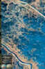
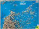
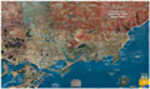
Standard Laminated Map Breton Sound & Delacroix Island Md#: M04724” X 36” Full Color Aerial Photo Maps Are Laminated. |
||
|
|
|||
|
|||
|
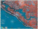
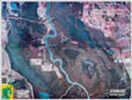
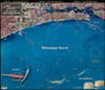
Standard Laminated Map Panama City Md#: MF12424” X 36” Full Color Aerial Photo Maps Are Laminated. |
||
|
|
|||
|
|||

|
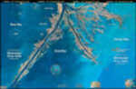
Standard Laminated Fast Fold Down River (Venice) Md#: M301The Fast Fold Maps Fold neatly Into 8 1/2 X 11 Inch StandardPaper Size. |
||
|
|
|||
|
|||

|
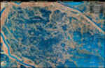
Standard Laminated Fast Fold Port Sulfhur To Buras Md#: M342The Fast Fold Maps Fold neatly Into 8 1/2 X 11 Inch StandardPaper Size. |
||
|
|
|||
|
|||

|
Standard Laminated Fast Fold Buras/Venice Md#: M343The Fast Fold Maps Fold neatly Into 8 1/2 X 11 Inch StandardPaper Size. |
||
|
|
|||
|
|||

|
Standard Laminated Fast Fold Grand Isle/Fourchon To 4 Bayou Md#: M344The Fast Fold Maps Fold neatly Into 8 1/2 X 11 Inch StandardPaper Size. |
||
|
|
|||
|
|||
|
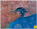
Standard Laminated Map Bay St. Louis Md#: M03924” X 36” Full Color Aerial Photo Maps Are Laminated. |
||
|
|
|||
|
|||

|
Standard Laminated Map Lafitte/Barataria Md#: M04024” X 36” Full Color Aerial Photo Maps Are Laminated. |
||
|
|
|||
|
|||
|
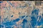
Standard Laminated Map Bayou Dularge Md#: M02024” X 36” Full Color Aerial Photo Maps Are Laminated. |
||
|
|
|||
|
|||
|
Standard Laminated Map La Marsh/Bayou Biloxi Md#: M05024” X 36” Full Color Aerial Photo Maps Are Laminated. |
||
|
|
|||
|
|||
|
Standard Laminated Map Sherburne Wildlife Management Area Md#: M05124” X 36” Full Color Aerial Photo Maps Are Laminated. |
||
|
|
|||
|
|||
|
Standard Laminated Map Down River Md#: M00124” X 36” Full Color Aerial Photo Maps Are Laminated. |
||
|
|
|||
|
|||
|
Standard Laminated Map Delacroix Island Md#: M00224” X 36” Full Color Aerial Photo Maps Are Laminated. |
||
|
|
|||
|
|||
|
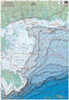
Standard Laminated Map Lower Pearl River Md#: M01224” X 36” Full Color Aerial Photo Maps Are Laminated. |
||
|
|
|||
|
|||
|
Standard Laminated Map Biloxi Miss Sound Md#: M02524” X 36” Full Color Aerial Photo Maps Are Laminated. |
||
|
|
|||
|
|||
|
Standard Laminated Map Chandeleur Block & Rig Chart Md#: M02624” X 36” Full Color Aerial Photo Maps Are Laminated. |
||
|
|
|||
|
|||

|
Standard Duck Chart Southern Water Fowl Md#: Dc00124” X 36” Full Color Aerial Photo Maps Are Laminated. |
||
|
|
|||
|
|||
|
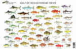
Standard Fish Chart Gulf Of Mexico Md#: FC00124” X 36” Full Color Aerial Photo Maps Are Laminated. |
||
|
|
|||
|
|||


|
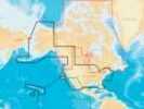
Navionics Hot Maps Chip Premium Freshwater EastMore Than 17,000 Total Lake Maps With Complete Fishing Information For Your GPS, Plus Over 1,000 High-Definition Lake Maps featuring Exclusive 1' cOntours From NaviOnics Own On-The-Water Surveys. Choo... |
||
|
|
|||
|
|||
|
Navionics Gold Chip All In One Usa Saltwater Chart2-Dimensional Gold Marine charts Are The Navigation Standard For Serious Mariners And Fishermen Offering The largest Coverage Areas For The widest Range Of Today's Most Popular chartplotters. Features... |
||
|
|
|||
|
|||

|
Navionics Nav+ All In One USANavionics+ Flexible Coverage - Micro Sd Get Detailed Chart Content For lakes And Marine areas, Plus Receive a 12 Month Subscription To Freshest Data For updates To The Nautical Charts, New SonarCharts... |
||
|
|
|||
|
|||

|
Navionics Nav Update All In One USAFlexible Coverage Selection online. Buy a Navionics Update Chip & Activate With Your Old Chart To Get Updates And Even Expand Your Navionics Coverage W/Flexible Chart Selection online. Get Detailed 2D... |
||
|
|
|||
|
|||


