CMOR Mapping NE FL & SC f/Simrad Lowrance Mercury
| Manufacturer | CMOR Mapping | |
| MFG NO | NFG002S | |
| SKU | 6084185 | |
| UPC | 850001904414 |
- SUMMARY
- SPECIFICATIONS
- MANUFACTURER
- REVIEWS
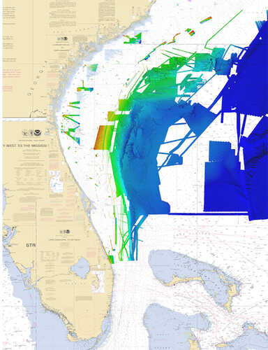
NE, FL & SC for Simrad, Lowrance & MercurySEE IT. DIVE IT. FISH IT.CMOR Mapping’s game-changing, high-resolution bathymetric imagery for Simrad, Lowrance, B & G, and Raymarine chartplotters and Mercury VesselView display brings the ocean floor into an entirely new level of focus for anglers and divers.COMPLETE COVERAGECMOR Mapping data comes from methodical surveys of the entire bottom with high-resolution echo sounders — not point soundings and historical records.UNPRECEDENTED DETAILWith resolution as high as 1 meter — meaning each pixel equals a square meter of bottom — we show you every ledge, coral head, and sunken culvert in unprecedented detail.SEAMLESS COMPATIBILITYJust insert a CMOR Mapping card into your plotter and zoom in to see bathymetric imagery. Your vessel icon shows your exact location relative to the bottom features.
| Specification | Value | |
|---|---|---|
| MFG NO | NFG002S | |
| SKU | 6084185 | |
| UPC | 850001904414 |

|
Standard Laminated Fast Fold Delacroix Island Md#: M302The Fast Fold Maps Fold neatly Into 8 1/2 X 11 Inch StandardPaper Size. |
||
|
|
|||
|
|||

|
Standard Laminated Fast Fold Chef Pass/Rigolets Md#: M307The Fast Fold Maps Fold neatly Into 8 1/2 X 11 Inch StandardPaper Size. |
||
|
|
|||
|
|||
|
Standard Laminated Map Breton Sound & Delacroix Island Md#: M04724” X 36” Full Color Aerial Photo Maps Are Laminated. |
||
|
|
|||
|
|||
CMOR Mapping NE FL & SC f/Simrad Lowrance Mercury
NE, FL & SC for Simrad, Lowrance & MercurySEE IT. DIVE IT. FISH IT.CMOR Mapping’s game-changing, high-resolution bathymetric imagery for Simrad, Lowrance, B & G, and Raymarine chartplotters and Mercury VesselView display brings the ocean floor into an entirely new level of focus for anglers and divers.COMPLETE COVERAGECMOR Mapping data comes from methodical surveys of the entire bottom with high-resolution echo sounders — not point soundings and historical records.UNPRECEDENTED DETAILWith resolution as high as 1 meter — meaning each pixel equals a square meter of bottom — we show you every ledge, coral head, and sunken culvert in unprecedented detail.SEAMLESS COMPATIBILITYJust insert a CMOR Mapping card into your plotter and zoom in to see bathymetric imagery. Your vessel icon shows your exact location relative to the bottom features.
Manufacturer CMOR Mapping
Mfg No NFG002S
SKU 6084185
UPC 850001904414



| 0 | Total: $0.00 |

|