Products by Navionics at LG Outdoors
LG Outdoors offers a wide variety of Navionics products at the best prices.

|
Navionics Hot Maps Chip Premium Freshwater EastMore Than 17,000 Total Lake Maps With Complete Fishing Information For Your GPS, Plus Over 1,000 High-Definition Lake Maps featuring Exclusive 1' cOntours From NaviOnics Own On-The-Water Surveys. Choo... |
||
|
|
|||
|
|||
|
Navionics Gold Chip All In One Usa Saltwater Chart2-Dimensional Gold Marine charts Are The Navigation Standard For Serious Mariners And Fishermen Offering The largest Coverage Areas For The widest Range Of Today's Most Popular chartplotters. Features... |
||
|
|
|||
|
|||

|
Navionics Nav+ All In One USANavionics+ Flexible Coverage - Micro Sd Get Detailed Chart Content For lakes And Marine areas, Plus Receive a 12 Month Subscription To Freshest Data For updates To The Nautical Charts, New SonarCharts... |
||
|
|
|||
|
|||

|
Navionics Nav Update All In One USAFlexible Coverage Selection online. Buy a Navionics Update Chip & Activate With Your Old Chart To Get Updates And Even Expand Your Navionics Coverage W/Flexible Chart Selection online. Get Detailed 2D... |
||
|
|
|||
|
|||

|
Navionics Hot Maps Plat North MSD/MMPT-N6HotMaps Platinum North enhances Premium's Extensive Library Of Lake Maps With 3D View, High resolution Top-Down photochart Overlay, Improved Accuracy, And Panoramic pictures. |
||
|
|
|||
|
|||

|
Navionics Hot Maps Plat East MSD/MMPT-E6HotMaps Platinum East enhances Premium's Extensive Library Of Lake Maps With 3D View, High resolution Top-Down photochart Overlay, Improved Accuracy, And Panoramic pictures. |
||
|
|
|||
|
|||
|
Navionics Hot Maps Plat South MSD/MMPT-S6HotMaps Platinum South enhances Premium's Extensive Library Of Lake Maps With 3D View, High resolution Top-Down photochart Overlay, Improved Accuracy, And Panoramic pictures. |
||
|
|
|||
|
|||

|
Navionics Hot Maps Prem South MSD/Prem-S6HotMaps Premium 2D South Map With More Underwater Structure Than Ever Before. Plug And Play Into Compatible Chart-plotters. |
||
|
|
|||
|
|||
|
|
Navionics + Map Plus Chip To Download All Information, Micro SdMunufacturer: NavioNics Model: MSd/NAV+Ni |
||
|
|
|||
|
|||
|
Navionics Hot Maps Prem East MSD/Prem-E6HotMaps Premium 2D East Map With More Underwater Structure Than Ever Before. Plug And Play Into Compatible Chart-plotters. |
||
|
|
|||
|
|||
|
Navionics Gold 1 All USA/BHMS MSD/1XGMarine Gold All-In-One 2D charts IncludIng USA And N. Bahamas And All features For Serious Fishing And cruisIng. |
||
|
|
|||
|
|||
|
Navionics Regions-East MSD/NAV+EANavionics+ Regions is a powerful electronic chart solution providing exceptional regional marine and lakes content. Get detailed Nautical Chart, SonarChart 1 ft HD bathymetry map, and Community Edits ... |
||
|
|
|||
|
|||
|
Navionics Regions-North MSD/NAV+NONavionics+ Regions is a powerful electronic chart solution providing exceptional regional marine and lakes content. Get detailed Nautical Chart, SonarChart1 ft HD bathymetry map, and Community Editspl... |
||
|
|
|||
|
|||
|
Navionics Regions-West MSD/NAV+WENavionics+ Regions is a powerful electronic chart solution providing exceptional regional marine and lakes content. Get detailed Nautical Chart, SonarChart 1 ft HD bathymetry map, and Community Edits ... |
||
|
|
|||
|
|||
|
Navionics Regions-South MSD/NAV+SONavionics+ Regions is a powerful electronic chart solution providing exceptonal regional marine and lakes content. Get detailed Nautical Chart, SonarChart 1 ftHD bathymetry map, and Community Edits pl... |
||
|
|
|||
|
|||
|
|
Navionics Update Map To Plus Chip, Micro SdMunufacturer: NavioNics Model: MSd/NAVU-Ni |
||
|
|
|||
|
|||

|
Naviocs Hot Maps Prem North MSD/Prem-N6HotMaps Premium 2D North Map With More Underwater Structure Than Ever Before. Plug And Play Into Compatible Chart-plotters. |
||
|
|
|||
|
|||
|
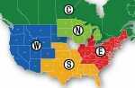
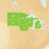
Navionics HotMaps Platinum Lake Maps - North - microSD™/SD™Hotmaps Platinum - North - microSD™/SD™North: Covers IA, MI, MN, WI, ND, SDLake Charts One foot contours21,000 lakes and growingDaily updates and advanced featur... |
||
|
|||
|
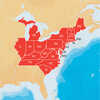
Navionics HotMaps Platinum Lake Maps - East - microSD™/SD™Hotmaps Platinum - East - microSD™/SD™East: Covers CT, DE, IL, IN, KY, MA, MD, ME, MI, NC, NH, NJ, NY, OH, PA, RI, SC, TN, VA, VT, WVLake Charts One foot contour... |
||
|
|||
|
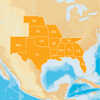
Navionics HotMaps Platinum Lake Maps South - microSD™/SD™Hotmaps Platinum - South - microSD™/SD™South: Covers AL, AR, FL, GA, KS, LA, MO, MS, NE, NM, OK, TX, TNLake Charts One foot contours21,000 lakes and growingDaily... |
||
|
|||
|
Navionics+ Preloaded Chart of All USA/Canada -Marine & Lakes- microSD™Navionics+ NAV+NI: Preprogrammed with All US & Canada - Marine & LakesMarine and lake chartsOne foot contours inshore and nearshore21,000 lakes and growingDaily updates and advanced features f... |
||
|
|||

|
Navionics+ Caribbean & South America - microSD™Caribbean & South America - microSD™Navionics+ provides more marine and lakes content and the best value!Charts - Everything on one card! Nautical Chart, SonarChart™ and Community Edit... |
||
|
|||

|
Navionics Navionics+ Regions - North - Preloaded MSD FormatNavionics+ Regions - North - Preloaded MSD FormatMarine and lake chartsOne foot contoursDaily updates and advanced features for one yearBoat safer and fish smarter. Max-detailed cartography for marine... |
||
|
|||

|
Navionics Navionics+ Regions - Canada & Alaska - Preloaded MSD FormatNavionics+ Regions - Canada & Alaska - Preloaded MSD FormatMarine and lake chartsOne foot contoursDaily updates and advanced features for one yearBoat safer and fish smarter. Max-detailed cartogra... |
||
|
|||


