Products by C-MAP at LG Outdoors
LG Outdoors offers a wide variety of C-MAP products at the best prices.
|
Lowrance C-MAP Lakes West Max-N+High-Resolution Bathymetric (HRB) bottom contour and fishing charts to help anglers target fish-holding coastal and offshore structure more effectively. The C-MAP Lakes West Max-N+ Insight Pro Chart i... |
||
|
|
|||
|
|||
|
Lowrance C-MAP Lakes North Central Max-N+High-Resolution Bathymetric (HRB) bottom contour and fishing charts to help anglers target fish-holding coastal and offshore structure more effectively. The C-MAP Lakes North Central Max-N+ Chart is o... |
||
|
|
|||
|
|||
|
Lowrance C-MAP Lakes North East Max-N+High-Resolution Bathymetric (HRB) bottom contour and fishing charts to help anglers target fish-holding coastal and offshore structure more effectively. The C-MAP Lakes North East Max-N+ Chart is on ... |
||
|
|
|||
|
|||
|
Lowrance C-MAP Lakes South East Max-N+High-Resolution Bathymetric (HRB) bottom contour and fishing charts to help anglers target fish-holding coastal and offshore structure more effectively. The C-MAP Lakes South East Max-N+ Chart is on a... |
||
|
|
|||
|
|||

|
Lowrance C-MAP Lakes South Central Max-N+High-Resolution Bathymetric (HRB) bottom contour and fishing charts to help anglers target fish-holding coastal and offshore structure more effectively. The C-MAX Lakes South Central Max-N+ Chart is o... |
||
|
|
|||
|
|||
|
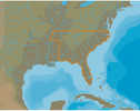
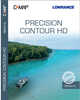
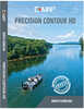
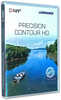
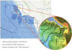
Lowrance C-MAP Precision Contour HD AlabamaThe C-MAP Precision Countour HD Alabama is the perfect mapping solution for tournament anglers. Precision Contour HD maps offer comprehensive coverage, including shallow backwaters and distant creek a... |
||
|
|
|||
|
|||
|
Lowrance C-MAP Precision Contour HD North CarolinaThe C-MAP Precision Contour HD North Carolina is the perfect mapping solution for tournament anglers. Precision Contour HD maps offer comprehensive coverage, including shallow backwaters and distant c... |
||
|
|
|||
|
|||
|
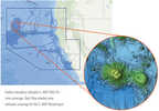
Lowrance C-MAP Precision Contour HD TennesseeThe C-MAP Precision Contour HD Tennessee is the perfect mapping solution for tournament anglers. Precision Contour HD maps offer comprehensive coverage, including shallow backwaters and distant creek ... |
||
|
|
|||
|
|||
|
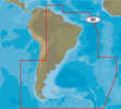
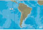
C-MAP 4D SA-D501 Gulf of Paria to Cape Horn4D SA-D501 Gulf of Paria to Cape HornWith C-MAP’s detailed cartography and extensive database of local information at your fingertips you’ll never be lost, even in unfamiliar waters.Domina... |
||
|
|||
|
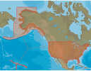
C-MAP MAX NA-M621 - Cape Blanco, OR-Puget Sound - SD™ CardNA-M621 => Cape Blanco to Puget SoundCoverage includes the offshore bathymetric details for the coasts of Oregon and Washington. Coverage actually starts around the Klamath River delta in California ... |
||
|
|||
|
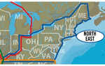
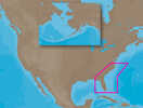
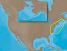
C-MAP MAX NA-M321 - Cape Henry, NC-Apalachicola, FL - SD™ CardNA-M321 => Cape Henry to Apalachicola BayCoverage includes offshore bathymetric details from Cape Henry, VA to Apalachicola Bay, FL. Coverage extends from the coastline out to the offshore Atlantic C... |
||
|
|||
|
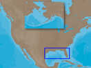
C-MAP MAX NA-M420 - Gulf of Mexico: Bathy - SD™ CardNA-M420 => Gulf of MexicoCoverage includes the offshore bathymetric details for the Gulf of Mexico from Key West, FL over and around to Brownsville, TX. Additional coverage up the eastern coast of Fl... |
||
|
|||
|
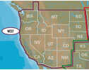
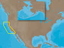
C-MAP MAX NA-M620 - San Diego, CA-Cape Blanco, OR - SD™ CardNA-M620 => San Diego to Cape BlancoCoverage includes the offshore bathymetric details for the coast of California and southern coast of Oregon, up to Cape Blanco. Complete coverage of the Channel Isl... |
||
|
|||
|
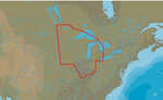
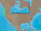
C-MAP MAX NA-M320 - Passamaquoddy Bay ME-NC: Bathy - SD™ CardNA-M320 => Passamaquoddy Bay to Cape LookoutCoverage includes offshore bathymetric details from Passamaquoddy Bay, ME to Cape Lookout, NC. Coverage extends from the coastline out to the Atlantic Cany... |
||
|
|||
|
C-MAP Reveal - US Pacific - San Diego to Santa Cruz CAReveal - US Pacific - San Diego to Santa Cruz CAPerfect for fishing and diving enthusiasts, C-MAP® Reveal charts deliver ultra, high-resolution images of structure, wrecks, isolated reefs and ledg... |
||
|
|||
|
C-MAP Reveal - US Pacific North California to South Oregon Point Sur Cape BlancoReveal - US Pacific - North California to South Oregon Point Sur CA to Cape Blanco ORPerfect for fishing and diving enthusiasts, C-MAP® Reveal charts deliver ultra, high-resolution images of struc... |
||
|
|||
|
C-MAP 4D SA-D500 Costa Rica to Chile to Falklands4D SA-D500 Costa Rica to Chile to FalklandsC-MAP charts have long been held in high regard by boaters because they combine aesthetically pleasing vector electronic charts with reliable sources.&n... |
||
|
|||
|
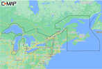
C-MAP M-NA-Y201-MS Great Lakes To Nova Scotia REVEAL™ Coastal ChartM-NA-Y201-MS Great Lakes To Nova Scotia REVEAL™ Coastal ChartWhether cruising or fishing, C-MAP REVEAL™ Coastal charts offer the very best of C-MAP. With Shaded Relief, including Reveal Se... |
||
|
|||
|
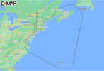
C-MAP M-NA-Y202-MS Nova Scotia to Chesapeake Bay REVEAL™ Coastal ChartM-NA-Y202-MS Nova Scotia to Chesapeake Bay REVEAL™ Coastal ChartWhether cruising or fishing, C-MAP REVEAL™ Coastal charts offer the very best of C-MAP. With Shaded Relief, including Reveal... |
||
|
|||
|
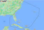
C-MAP M-NA-Y203-MS Chesapeake Bay to Bahamas REVEAL™ Coastal ChartM-NA-Y203-MS Chesapeake Bay to Bahamas REVEAL™ Coastal ChartWhether cruising or fishing, C-MAP REVEAL™ Coastal charts offer the very best of C-MAP. With Shaded Relief, including Reveal Sea... |
||
|
|||
|
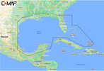
C-MAP M-NA-Y204-MS Gulf of Mexico to Bahamas REVEAL™ Coastal ChartM-NA-Y204-MS Gulf of Mexico to Bahamas REVEAL™ Coastal ChartWhether cruising or fishing, C-MAP REVEAL™ Coastal charts offer the very best of C-MAP. With Shaded Relief, including Reveal Sea... |
||
|
|||
|
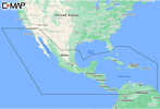
C-MAP M-NA-Y205-MS Central America & Caribbean REVEAL™ Coastal ChartM-NA-Y205-MS Central America & Caribbean REVEAL™ Coastal ChartWhether cruising or fishing, C-MAP REVEAL™ Coastal charts offer the very best of C-MAP. With Shaded Relief, including Reve... |
||
|
|||
|
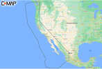
C-MAP M-NA-Y206-MS West Coast & Baja California REVEAL™ Coastal Chart - Does NOT contain HawaiiM-NA-Y206-MS West Coast & Baja California REVEAL™ Coastal Chart - Does NOT contain HawaiiWhether cruising or fishing, C-MAP REVEAL™ Coastal charts offer the very best of C-MAP. With Sh... |
||
|
|||
|
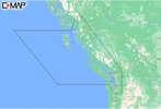
C-MAP M-NA-Y207-MS Columbia & Puget Sound REVEAL™ Coastal ChartM-NA-Y207-MS Columbia & Puget Sound REVEAL™ Coastal ChartWhether cruising or fishing, C-MAP® REVEAL™ Coastal charts offer the very best of C-MAP. With Shaded Relief, including Reve... |
||
|
|||


