


Humminbird LakeMaster Chart - Woods/Rainy - MicroSD/SD
| Manufacturer | Humminbird | |
| MFG NO | 600027-2 | |
| SKU | 5931080 | |
| UPC | 082324046551 |
- SUMMARY
- SPECIFICATIONS
- MANUFACTURER
- REVIEWS
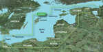
LakeMaster Chart - Woods/Rainy - MicroSD/SDThe LakeMaster; Woods/Rainy Humminbird™ compatible Version 4 map card now brings the ground-breaking technology of "Follow the Contour" to your fingertips. The SD map card, when combined with a compatible i-Pilot; Link™ system, allows you to choose a path directly on or offset from any contour and automatically navigate it letting you focus on fishing more than ever before. The Version 4 card has High Definition accuracy and detail, combined with exclusive features for Humminbird GPS units, giving anglers updated surveyed areas around Big Island on the SE portion of the lake. With named structure, detailed roads, island labels, colored buoys, marked rocks and hazards and of course High Definition contours, Version 4 is the ultimate mapping card for any angler traveling to the border.What's Covered?High definition 1' Contours for nearly all of Lake of the Woods. The detail covers all U.S and Canadian water from Big Narrows through Big Traverse & Sabaskong Bays North to Sioux Narrows and West beyond Deadbroke channel (810,000 total surveyed acres).Also Includes:Blueberry Inlet, Deadbroke Channel, Long Bay, Sunset Channel, Black Sturgeon Bay & Yellow Girl BayRainy Lake & the Rainy River with High Definition 1ft contours for Redgut & Rice Bay, all of Lakes Kabetogama, Namakan, Sand Point and Crane lakePlus i-Pilot; Link™ compatibleWARNING: This product can expose you to chemicals including Naphthalene which is known to the State of California to cause cancer. For more information go to P65Warnings.ca.gov.
| Specification | Value | |
|---|---|---|
| MFG NO | 600027-2 | |
| SKU | 5931080 | |
| UPC | 082324046551 |
| Humminbird | ||
| Phone: | ||
| Email: | ||
| Website: | http://www.humminbird.com | |
| Address: |
678 Humminbird Lane Eufaula, AL 36027 |
|
|
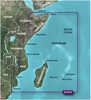
Garmin BlueChart; g2 HD - HXAF001R - Eastern Africa - microSD™/SD™BlueChart® g2 HD - HXAF001R - Eastern Africa - microSD™/SD™Coverage:General coverage of the east coast of Africa from the Gulf of Tadjoura to the Bay of Maputo, including Mogadishu, So... |
||||||
|
FLAT SHIPPING!
|
|||||||
|
PRICE $118.94
QTY
ADD TO CART
|
|||||||
|
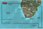
Garmin BlueChart; g2 HD - HXAF002R - South Africa - microSD™/SD™BlueChart® g2 HD - HXAF002R - South Africa - microSD™/SD™Coverage:Detailed coverage of the coast of southern Africa from Namibe, Ang. to Angoche, Moz., including the South African citi... |
||||||
|
FLAT SHIPPING!
|
|||||||
|
PRICE $118.94
QTY
ADD TO CART
|
|||||||
|
Garmin BlueChart; g2 HD - HXEU065R - Baltic Sea East Coast - microSD™/SD™BlueChart® g2 HD - HXEU065R - Baltic Sea East Coast - microSD™/SD™Coverage:Coverage of the coasts of the Estonia, Latvia, Lithuania, Russia, and Poland from Narva-Joesuu, Est. to Rugen... |
||||||
|
FLAT SHIPPING!
|
|||||||
|
PRICE $118.94
QTY
ADD TO CART
|
|||||||
Humminbird LakeMaster Chart - Woods/Rainy - MicroSD/SD
LakeMaster Chart - Woods/Rainy - MicroSD/SDThe LakeMaster; Woods/Rainy Humminbird™ compatible Version 4 map card now brings the ground-breaking technology of "Follow the Contour" to your fingertips. The SD map card, when combined with a compatible i-Pilot; Link™ system, allows you to choose a path directly on or offset from any contour and automatically navigate it letting you focus on fishing more than ever before. The Version 4 card has High Definition accuracy and detail, combined with exclusive features for Humminbird GPS units, giving anglers updated surveyed areas around Big Island on the SE portion of the lake. With named structure, detailed roads, island labels, colored buoys, marked rocks and hazards and of course High Definition contours, Version 4 is the ultimate mapping card for any angler traveling to the border.What's Covered?High definition 1' Contours for nearly all of Lake of the Woods. The detail covers all U.S and Canadian water from Big Narrows through Big Traverse & Sabaskong Bays North to Sioux Narrows and West beyond Deadbroke channel (810,000 total surveyed acres).Also Includes:Blueberry Inlet, Deadbroke Channel, Long Bay, Sunset Channel, Black Sturgeon Bay & Yellow Girl BayRainy Lake & the Rainy River with High Definition 1ft contours for Redgut & Rice Bay, all of Lakes Kabetogama, Namakan, Sand Point and Crane lakePlus i-Pilot; Link™ compatibleWARNING: This product can expose you to chemicals including Naphthalene which is known to the State of California to cause cancer. For more information go to P65Warnings.ca.gov.
Manufacturer Humminbird
Mfg No 600027-2
SKU 5931080
UPC 082324046551


| 0 | Total: $0.00 |
|
|

