

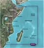
Garmin BlueChart; g3 Vision; VEI510S - Dnieper River & Azov Sea - microSD™/SD™
| Manufacturer | Garmin | |
| MFG NO | 010-C1128-00 | |
| SKU | 5927852 | |
| UPC | 753759145651 |
- SUMMARY
- SPECIFICATIONS
- MANUFACTURER
- REVIEWS
BlueChart; g3 Vision; VEI510S - Dnieper River & Azov Sea Coverage: Detailed coverage of the Dnieper River from the Belarus-Ukrainian border to the Black Sea, the Sea of Azov and the Black Sea coast from the Danube Delta to Sochi, Russia, including the entire Crimean coast. Coverage includes the Kuban River to Krasnodar, the Kerch Strait, the Don River to Bagayevskiy and the Danube River to Braila, Romania.See your vessel’s precise, on-chart position in relation to navaids, coastal features and restricted areas with premium features found in this detailed marine mapping data. Includes all of the features of our BlueChart; g2 HD product, plus 3-D perspective above and below the waterline, Auto Guidance, high-resolution imagery, and aerial photos of ports, harbors, marinas and landmarks.Features:Shaded depth contours, coastlines, spot soundings, navaids, port plans, wrecks, obstructions, intertidal zones, restricted areas and IALA symbolsFeatures up to 1-foot HD fishing contours which reveal detailed seafloor terrainSeamless transitions between zoom levels and more continuity across chart boundariesHigh resolution satellite imagery for a realistic view of the land and wateAerial photos of ports, harbors, marinas, waterways, navigational landmarks and other POIsGarmin Auto Guidance technology is now capable of providing routing guidance¹ to virtually any accessible destination on the waterMariner’s Eye view 3-D perspective for a quick, easy position fixFish Eye view 3-D perspective for an underwater view of the sea floorSafety Shading* enables contour shading for all depth contours shallower than your defined safe depthsFishing Charts* to scope out bottom contours and depth soundings with less visual clutter on the displayPlan and organize routes from your computer with HomePort™WARNING: This product can expose you to chemicals which are known to the State of California to cause cancer, birth defects or other reproductive harm. For more information go to P65Warnings.ca.gov.
| Specification | Value | |
|---|---|---|
| MFG NO | 010-C1128-00 | |
| SKU | 5927852 | |
| UPC | 753759145651 |
| Garmin | ||
| Phone: | 913-397-8200 | |
| Email: | ||
| Website: | http://www.garmin.com | |
| Address: |
1200 East 151st Street Olathe, KS 66062 |
|
|
Garmin BlueChart; g2 HD - HXAF001R - Eastern Africa - microSD™/SD™BlueChart® g2 HD - HXAF001R - Eastern Africa - microSD™/SD™Coverage:General coverage of the east coast of Africa from the Gulf of Tadjoura to the Bay of Maputo, including Mogadishu, So... |
||||||
|
FLAT SHIPPING!
|
|||||||
|
PRICE $118.94
QTY
ADD TO CART
|
|||||||
|
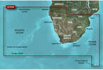
Garmin BlueChart; g2 HD - HXAF002R - South Africa - microSD™/SD™BlueChart® g2 HD - HXAF002R - South Africa - microSD™/SD™Coverage:Detailed coverage of the coast of southern Africa from Namibe, Ang. to Angoche, Moz., including the South African citi... |
||||||
|
FLAT SHIPPING!
|
|||||||
|
PRICE $118.94
QTY
ADD TO CART
|
|||||||
|
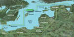
Garmin BlueChart; g2 HD - HXEU065R - Baltic Sea East Coast - microSD™/SD™BlueChart® g2 HD - HXEU065R - Baltic Sea East Coast - microSD™/SD™Coverage:Coverage of the coasts of the Estonia, Latvia, Lithuania, Russia, and Poland from Narva-Joesuu, Est. to Rugen... |
||||||
|
FLAT SHIPPING!
|
|||||||
|
PRICE $118.94
QTY
ADD TO CART
|
|||||||
Garmin BlueChart; g3 Vision; VEI510S - Dnieper River & Azov Sea - microSD™/SD™
BlueChart; g3 Vision; VEI510S - Dnieper River & Azov Sea Coverage: Detailed coverage of the Dnieper River from the Belarus-Ukrainian border to the Black Sea, the Sea of Azov and the Black Sea coast from the Danube Delta to Sochi, Russia, including the entire Crimean coast. Coverage includes the Kuban River to Krasnodar, the Kerch Strait, the Don River to Bagayevskiy and the Danube River to Braila, Romania.See your vessel’s precise, on-chart position in relation to navaids, coastal features and restricted areas with premium features found in this detailed marine mapping data. Includes all of the features of our BlueChart; g2 HD product, plus 3-D perspective above and below the waterline, Auto Guidance, high-resolution imagery, and aerial photos of ports, harbors, marinas and landmarks.Features:Shaded depth contours, coastlines, spot soundings, navaids, port plans, wrecks, obstructions, intertidal zones, restricted areas and IALA symbolsFeatures up to 1-foot HD fishing contours which reveal detailed seafloor terrainSeamless transitions between zoom levels and more continuity across chart boundariesHigh resolution satellite imagery for a realistic view of the land and wateAerial photos of ports, harbors, marinas, waterways, navigational landmarks and other POIsGarmin Auto Guidance technology is now capable of providing routing guidance¹ to virtually any accessible destination on the waterMariner’s Eye view 3-D perspective for a quick, easy position fixFish Eye view 3-D perspective for an underwater view of the sea floorSafety Shading* enables contour shading for all depth contours shallower than your defined safe depthsFishing Charts* to scope out bottom contours and depth soundings with less visual clutter on the displayPlan and organize routes from your computer with HomePort™WARNING: This product can expose you to chemicals which are known to the State of California to cause cancer, birth defects or other reproductive harm. For more information go to P65Warnings.ca.gov.
Manufacturer Garmin
Mfg No 010-C1128-00
SKU 5927852
UPC 753759145651


| 0 | Total: $0.00 |
|
|

